

National Weather Service Upgrades Severe Weather Risk For Oklahoma Ahead Of Storm
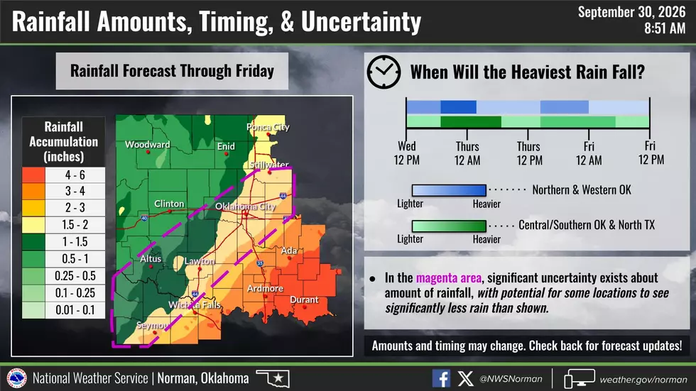
UPDATE, 11 a.m. Wednesday, Sept. 30: Significant uncertainty remains for rainfall amounts and timing in Lawton on Wednesday, Sept. 30. According to the National Weather Service in Norman, Lawton and portions along the I-44 corridor continue to show "significant uncertainty" for amounts of rainfall on Wednesday. It is possible that possible that areas could see significantly less rainfall than expected.
The National Weather Service in Norman has reduced the amount of rainfall expected in Lawton from 2-3 inches of rain to 1.5 to 2 inches. However, due to the significant uncertainty, it's possible that Lawton will either receive less or more rain than anticipated.
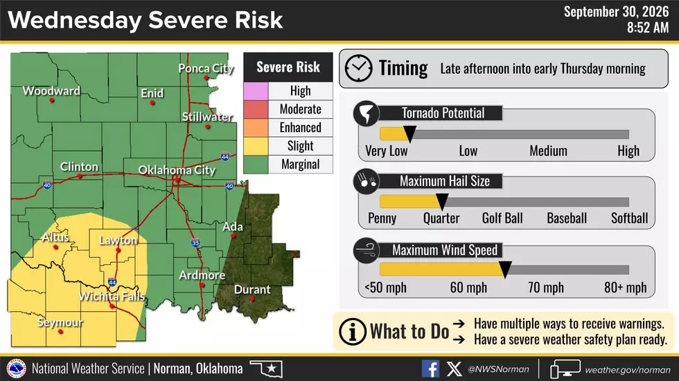
Lawton does continue to remain in the Slight Risk area for severe weather on Wednesday. Storms are expected to develop in the late afternoon and continue into the late evening hours. A very low tornado potential remains. Main hazards continue to be quarter-sized hail, damaging winds from 60 to 70 miles per hour and very heavy rainfall.
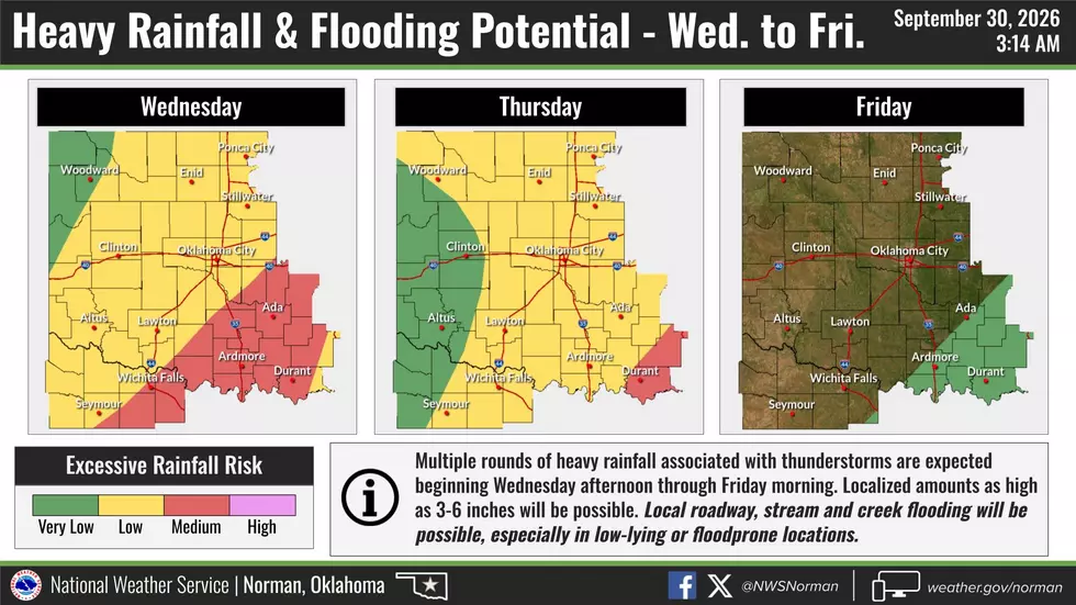
The National Weather Service in Norman has reduced Lawton's Excessive Rainfall Risk from Medium to Low for Wednesday. A low risk for excessive rainfall will also continue into Thursday for Lawton.
Lawton residents are still encouraged to remain weather aware and have multiple ways to receive weather alerts. For more information about the latest forecast, visit the National Weather Service in Norman's official website.
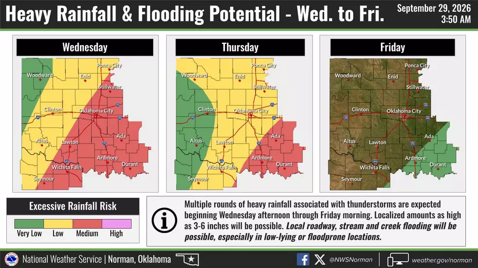
UPDATE, 4:05 p.m. Tuesday, Sept. 29: Heavy rainfall and flooding chances have increased for Lawton on Wednesday, Sept. 30. According to the National Weather Service in Norman, Lawton and portions of southwest Oklahoma are at a Moderate Risk for excessive rainfall on Wednesday and a Slight Risk on Thursday. Multiple rounds of thunderstorms starting Wednesday afternoon are expected to bring several bouts of heavy rainfall through Thursday.
Localized amounts of rainfall could range from three to six inches. Localized flooding is possible in low-lying and flood-prone areas. As of 4 p.m. Tuesday, Sept. 29, Lawton and Comanche County are not included in the Flood Watch issued by the National Weather Service in Norman.
As of Tuesday afternoon, the National Weather Service in Norman has Lawton in an area of "significant uncertainty" for the amount and timing of rainfall. The weather service is expecting Lawton to receive 2-3 inches of rain, however, some locations may see little to no precipitation. But the forecast is expected to change, so residents are encouraged to remain weather aware.

The National Weather Service in Norman has also moved the Slight Severe Risk back to south of I-40. However, Lawton is still within the Slight Severe Risk for severe storms on Wednesday. Starting Wednesday afternoon, the environment will be favorable for severe weather, including damaging winds from 60-70 miles per hour, quarter-sized hail, and heavy rainfall. A very low tornado risk is also possible for the overnight hours on Wednesday.
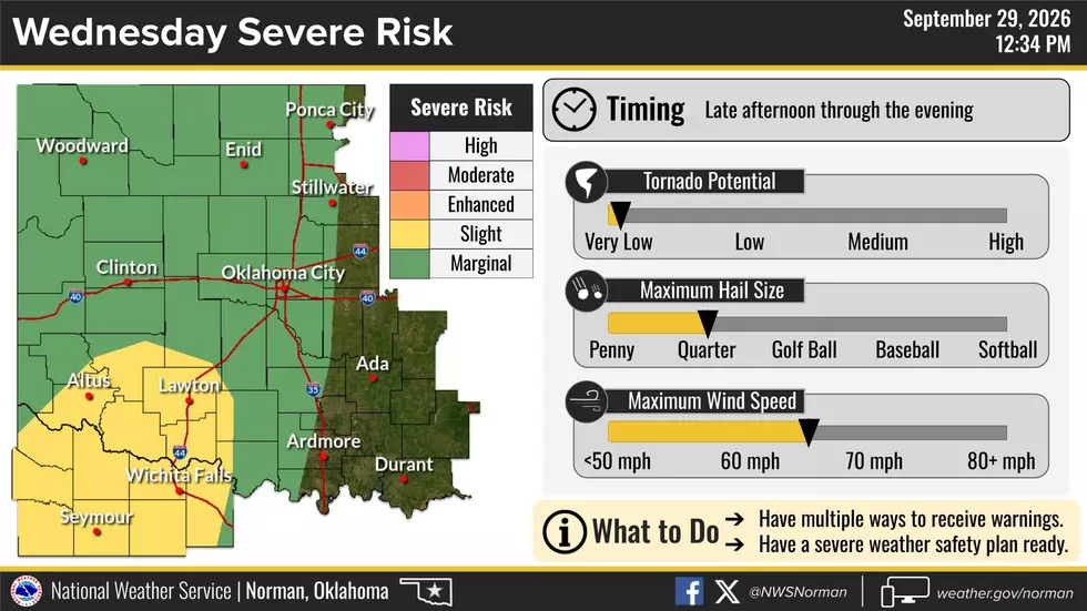
Oklahoma residents are still encouraged to pay attention to local weather officials as forecasts are expected to change. Residents should also prepare for severe weather by having multiple ways to receive weather updates and review safety procedures.
More details about this week's severe weather can be found on the National Weather Service in Norman's official website.
Original Published at 1:48 p.m. Monday, Sept. 28
Remnants of Hurricane Polo are headed towards Oklahoma this week, and Lawton is directly in the line of severe weather. As the hurricane made its way into Mexico over the weekend, local meteorologists began steadily tracking its potential impact on Oklahoma. As we get closer to Wednesday, the forecast becomes more clear, and as of Monday, the National Weather Service in Norman is expecting the weather to turn severe.
Over the weekend, the main conversation about Hurricane Polo's impact on Oklahoma focused on heavy rain and potential flooding. But as of Monday, Sept. 28, the National Weather Service in Norman is now expecting severe weather to return to western and southwest Oklahoma. Potential hazards include damaging winds, tornadoes, large hail and very heavy rainfall.
Oklahoma Severe Weather Forecast
The National Weather Service in Norman has upgraded the event to a Slight Severe Risk for areas of western and southwest Oklahoma, including Lawton. As of Monday, the Slight Risk stretches from the Oklahoma/Texas border to north of I-40 and east of I-45.
Severe storms are expected to develop Wednesday afternoon and continue through the evening hours and into Thursday morning. The forecast is expected to change as we get closer to Wednesday.
Lawton Flood Zones
With very heavy rain expected, Lawton citizens will want to be prepared for localized flooding, along with the other potential hazards expected with the incoming severe weather. According to the City of Lawton, over 30 areas across the city are prone to flooding during heavy rain events.
- 2nd Street and F Avenue
- NW Santa Fe and NW 40th
- Cache Road at Wolf Creek
- Indian Trail Rd near NW Morningside
- NE Rogers Lane
- NE Flower Mound between NE Brentwood and NE Lancaster Dr
- NE 20th St
- NE 15th St north of Gore Blvd
- Numerous locations between NE 13th St and NE 14th St
- NW Ferris between NW Ft Sill Blvd and NW 14th St
- NW 24th St north of Gore Blvd
- NW 25th St north of Gore Blvd
- NW 26th St north of Gore Blvd
- W Gore Blvd between NW 24th St and NW 26th St
- NW Columbia to include NW 53rd
- NE Flower Mound between NE Brentwood and NE Lancaster Dr
- SW F Ave west of 11th St
- SW E Ave west of 11th St
- SW Park Ave between SW 14th and SW 16th
- SW Lee Blvd at Numu Creek
- SE Flower Mound north of Lee Blvd and south of Gore Blvd
- S Railroad south of Lee Blvd
- SW Wolf St south of LEE Blvd
- SW Bishop east of SW 34th St
- SW 52nd St north of Kingston Dr
- SW 67th St north of Majestic Oak
- SW 38th St north/south of Lee Blvd, including Lee Blvd
- NE Laurie Tatum Rd north of Gore Blvd
- NW Meadowbrook near 50th St and 51st St
- NW Sheridan and Gore Blvd
- NW Lake Ave and NW 15th St
- SW I Ave between SW 6th St and SW 2nd St
- NW 49th St and NW Pollard Ave
If Lawton residents come across flooding, drivers should not drive through flood roadways. If drivers become stranded, they should immediately call 911.

Severe Weather Preparedness
The National Weather Service in Norman is encouraging residents to begin preparations now for Wednesday's severe weather event. People should have multiple ways to receive weather warnings and review severe weather safety plans.
To stay up-to-date on the latest forecast, follow the National Weather Service in Norman on Facebook or visit the storm prediction center's official website.
READ MORE
- Five Ways To Prepare For Storm Season In Oklahoma
- Nighttime Tornado Safety: Tips For Preparedness And Alerts
- How To Prepare Your Storm Cellar For Tornado Season
- How To Register Your Storm Shelter With First Responders In Oklahoma
Things Oklahomas Need To Know Before Severe Weather Strikes
Gallery Credit: Dani
Things You'll Need in Your Oklahoma Tornado Prep Kit
Gallery Credit: Kelso
More From KLAW-FM