
Meteorologists Stunned By Record-breaking Tornado Near Hollister
Meteorologists and storm chasers from all over the nation are perplexed by a tornado that recently touched down in Oklahoma. On Tuesday, April 30, five tornadoes touched down in southwest Oklahoma, taking residents and meteorologists by surprise. But there was one tornado that left them speechless.
Where was the most powerful tornado ever spotted in Oklahoma?
Meteorologists across the state in Oklahoma were covering the events in southwest Oklahoma, even if it was out of their coverage area. Oklahomans who were watching News9 Chief Meteorologist David Payne were in for over seven hours of severe thunderstorm wall-to-wall coverage.
Storms started developing in western Oklahoma just after 4 p.m. that day and began popping up in southwest Oklahoma within the hour. Areas within Tillman county were under a tornado warning for a majority of the evening with 10 tornado warnings in total.
But there were two tornadoes that touched down in Tillman county that have awed meteorologists across the country. And one is being considered the strongest tornadoes to ever touch down.
Dangerous tornado touched down near Hollister, Oklahoma.
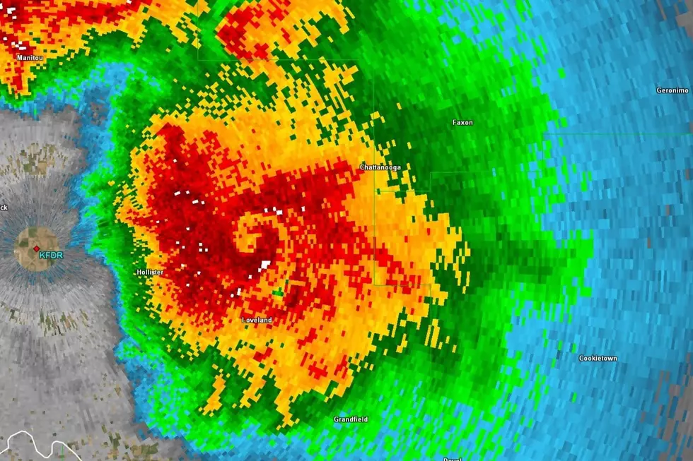
As storms began to shift south off their north-northeast path, that's when storms began to do weird things in Tillman county. While watching the storms shift, Payne noticed a tornado beginning to form northwest of Hollister, Oklahoma.
Around 9:42 p.m. Payne was monitoring the velocity rates of the storm near Hollister, Oklahoma, and pointed to the tornado saying, "that's a problem. That's dangerous." It was one of the strongest velocity couplets they had seen that day. At that moment, it was four miles northeast of Hollister. The debris detector indicated a tornado was on the ground.
Payne and his team followed this tornado during its entire course as it grew and grew, determining it as the strongest tornado of the day. As it moved due east at 9:44 p.m., Payne urged Oklahomans in the area to get underground, stating that this tornado "might be a strong, violent tornado. Anywhere from an EF1 to maybe an EF3 or greater."
Then debris began to increase.
Payne and his team determined that it had been one of the biggest debris signatures they had seen since Sulphur was struck on Saturday, April 28. By then, HWY 5 and Loveland were in the path of the storm that was headed due north.
Payne then asked his team to look at how high the debris was. As the winds increased Payne said, "this is a tornado that will kill you." The violent and dangerous tornado was wrapped in rain as it began to move across the countryside of southwest Oklahoma. Even though it wasn't plowing through a town or city, there were still farms with farmhouses being impacted by the powerful tornado.
"This is a tornado that if you don't take your precautions, you could die," Payne urged to his viewers at 9:48 p.m.
Violent tornado is slow and rain-wrapped.
As the strong tornado moved north-northeast, it was headed to cross HWY5 and move up towards Chattanooga. The debris ball just getting bigger and bigger as it moved. Lacey Swope, News9 Meteorologist, said, "it's picking up everything it's hitting right now."
When they flipped to reflectivity, it was impossible to see the massive tornado because it was so rain-wrapped. Which means it couldn't be seen from the ground.
"It's completely wrapped in rain," Payne said. "It's a ball of cause doing destruction."
When they turned back to velocity and widened the shot of the whole state. The tornado was obvious as you could see the gigantic tornado twisting over southwest Oklahoma - the entire storm system feeding into it.

"This is a strong, strong tornado," Payne said. "... It looks like a hurricane."
The debris ball continued to increase as the tornado continued on the ground by 9:52 p.m. The meteorologists assumed the tornado was moving 10-15 miles per hour, which means the damage from the tornado would be huge because it's staying on top of areas longer.
By 9:54 p.m. the tornado started trying to lift north-northeast after going due east. The meteorologists with News9 measured the tornado's winds at about 140 to 150 miles per hour below, which according to Payne, would categorize it as an EF2 or EF3.
"I'm really worried right now," Payne said.
As the hour creeped closer to 10 p.m., the storm had not weakened. Scan by scan the tornado grew and grew. It became more stationary and wider, picking up more debris.
"This land, where it is, is going to be scarred," Payne said.
By 10 p.m. the debris ball became more apparent, anything and everything in the rural area. But by 10:01 p.m. it appeared to weaken as it jumped north.
Hole of violent tornado shows on radar.
As it makes a sudden hard left turn, the tornado shifted north, and looking at the reflectivity radar, a hole was present. Which meant there was no precipitation inside the eye of the tornado.
Hail and heavy rain were completely wrapped around the tornado. When the tornado was pulled north it began to fold. A bounded reach echo region formed, and Swope stated, "that's not something you want to see."

"That is a big, bad tornado," Payne said. By 10:07 p.m. the winds decreased with the tornado but a hole was still present on the radar. The size began to shrink from half a mile wide to and eighth of a mile wide, but that didn't mean that it wasn't strong.
Another tornado begins to form.
While the violent tornado was ongoing, a portion of the storm split and started developing circulation southeast of Loveland around 10:09 p.m. The second tornado was showing to be anticyclonic, which means the tornado is moving clockwise - tornadoes move counter clockwise - this is extremely rare.
Tornado does the weirdest thing.
Back to the tornado near HWY 5, heading for Chattanooga, the tornado makes a complete loop. It was going due east, turned north and then jumped back west - making a backwards "c" motion with its path. Almost doing a complete circle.
By 10:11 p.m. the tornado appeared like it was trying to kill itself. The hole of the tornado was still present on the reflectivity radar. At 10:14 p.m. the tornado had disappeared.
"There were some bad things walking the earth for the last 30 to 35 minutes," Payne said.
Anticyclonic tornado continues to move.
As the other tornado began to weaken, the anticyclonic tornado continued to move southeast of Loveland, towards Grandfield.
According to the National Weather Service, only about 1 percent of tornadoes become anticyclonic. And the one the anticyclonic tornado that emerged in Tillman county was not only rare, but it was powerful. A CNN article interviewed a representative from the National Weather Service in Norman, who stated that since it came from the southern edge of the other violent tornado that "it's likely these two tornadoes were briefly active at the same time."
By 10:25 p.m. the debris cloud of the anticyclonic tornado was inching closer to Grandfield. The storm itself was moving slowly and was nearly stationary as it made its way south.
"To get a strong anticyclonic tornado, or a backwards spinning tornado, that is giving us debris? Now we're getting weird," Payne said.
As 10:30 p.m. approached, the anticyclonic tornado was headed straight for Grandfield at 15 miles per hour. And meteorologists were urging residents to take cover.
"It's spinning backwards. It's rare. And they're usually not this strong," Payne said.
By 10:32 p.m. the anticyclonic tornado began to shift southwest, appearing on its way to clip the western side of Grandfield. At 10:33 p.m. News9 received an update from the National Weather Service in Norman stating that they were seeing debris from the anticyclonic tornado at 10,000 feet above ground.
By 10:34 p.m. the velocity radar showed that the tornado had then split in two - producing an anticyclonic and cyclonic tornado simultaneously.
"Are you kidding me," Payne said.
"This is a strong tornado. Not violent like the other one. But strong," Payne said.
At 10:37 p.m. it began to look like the anticyclonic tornado was weakening. By 10:41 p.m. the tornado was gone before hitting west of Grandfield.
Data collected after the storms shows most powerful tornado ever.
For those living in Tillman county and those watching the wall-to-wall coverage, it was a long and wild night for severe weather and tornadoes. Days after the storm is when data started being collected and began to shine a bigger light on actually how bad these two tornadoes were.
Although the damage assessed for the violent tornado northeast of Hollister was categorized as an EF1, the data from the atmosphere above points out to how dangerous the tornado actually was.
Storm Chaser Adam Lucio was fascinated by the radar images from the violent tornado. On their Facebook page, they stated that the image with the post was a level 12 radar tilt from roughly 18,000 feet up. They explained that rotation from an EF4 tornado has been observed anywhere from 10,000 to 12,000 feet.
Lucio commented that this was "likely one of the most powerful tornadoes ever to occur." But since it hit "basically nothing" we will never truly know. People in the comments asked for pictures of the physical tornado, but Lucio responded that other storm chasers were in the area that night and said it was barely visible, cloaked in rain.
Meteorologist Eric Graves stated that based on these tornadoes, the EF scale needs to be amended to not just measure based on damage. They stated that "one of the most powerful tornadoes on Earth occurred just east of Hollister, Oklahoma."
The gate velocities were over 260 miles per hour, a vortex hole like the eye of a hurricane and the swirl could be seen from 18,000 feet. Graves said if anything would have been hit by this tornado, it would've been completely gone.
Oklahoma's Top 10 Deadliest Tornadoes
Gallery Credit: Kaley Patterson
The Ten Most Tornado-Prone Counties in America
Gallery Credit: Kelso
More From KLAW-FM